

Biostratigraphy allowed correlation worldwide. As knowledge of index fossils increased, geologists were able to form a global set of sequence of appearances (and disappearances) of fossils through the geologic strata. The fundamental unit of biostratigraphy is the biozone (sometimes simply the zone), defined as the body of rock between the first appearance datum (FAD) and last appearance datum (LAD) of an index fossil species.
Work on biozones from around the globe during the 19th Century allowed them to be grouped together into a universal scale: the Geologic Timescale (For a more detailed version, go here.)
Two aspects to the Geologic Timescale:
The basic chronostratigraphic unit is the System. Each system is comprised of two or three Series; each Series is comprised of two or more Stages. The boundary between Systems is instantaneous (represents 0 time) and isochronous (the same everywhere).
The basic geochronologic unit is the Period: that chunk of time between the first deposition of a particular System and the start of deposition of the next system. The geochronologic equivalent to the Series is the Epoch, and to the Stage is the Age.
Geologic Timescale Grammar:
In 1841 John Phillips grouped Periods into larger units called Eras based on characteristic groups of fossils: the Paleozoic (ancient animal life), Mesozoic (middle animal life), and Cenozoic (recent animal life) Eras. These were based on overall patterns of the changing relative abundance of major types of invertebrates. In particular, the boundaries between the Paleozoic and Mesozoic Eras and the Mesozoic and Cenozoic Eras were major turnovers of the marine realm (as it turns out, major mass extinctions).
Later still, in the 1930s Eras are then grouped into Eons: the largest geochronologic units. Chronostratigraphic equivalents are the Erathem and Eonthem (almost never used professionally: only show up in Historical Geology & Stratigraphy classes).
Here is the hierarchy of units:
| Chronostratigraphic Units | Geochronologic Units | ||||||||||
|---|---|---|---|---|---|---|---|---|---|---|---|
| (Divisions of Rock) | (Divisions of Time)
| Eonthem | Eon
| Erathem | Era
| System | Period
| Series | Epoch
| Stage | Age (although the International Commission on Stratigraphy proposes to replace this with "Stage")
| |
21st Century Chronostratigraphy: GSSPs and GSSAs
Boundaries between chronostratigraphic (and consquently geochronologic) units have been argued over for scientific (and often personal or
political) reasons. A type locality is selected and criteria for the lower boundary of the unit is set, as in lithostratigraphy. In
recent years, the type locality concept for chronostratigraphic units have been refined to become the Global Boundary Stratotype Section and Point
(abbreviated GSSP) concept. GSSPs are typically defined by faunal changes, although often a geochemical signature is found which is stratigraphically
near to the faunal change for additional potential correlation. Ideally, a GSSP should have the following attributes:
Stratigraphers are currently engaged in finding GSSPs for previously established Stage boundaries (or, in the case of the Cambrian, replacing old Stages with new ones supportable by GSSPs). About half of the Phanerozoic GSSPs have been assigned already: for an update, go to the GSSP page of the International Commission on Stratigraphy.
In the late 20th and 21st Centuries, official subdivisions of the Precambrian have been proposed. For the youngest two (Ediacaran and Cryogenian Systems) there are plans to find GSSPs for the boundaries. For these, however, boundaries are often arbitrarily selected chronometric dates called Global Standard Stratigraphic Ages (GSSAs).
While the geological timescale using the above system is the predominant one in the science, there are a few useful parallel systems:
I. Magnetostratigraphy
The fundamental unit in magentostratigraphy is the chron: within each chron there
is an N (normal polarity) and R (reversed polatity) subcrhon. The youngest chrons have their
own unique names, but most are referred to by just their number (increasing further back in
time). Because the continuous marine record only extends back to the Jurassic andCretaceous, magnetostratigraphy
is less useful in deeper time than other chronostratigraphy.
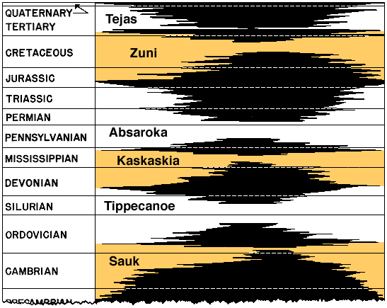
II. Sequence Stratigraphy
The fundamental unit is the sequence, whose boundaries are unconformities. Each sequence represents
a transgressive-regressive couplet, on various scales. The most complete set is worked out for
Phanerozoic continental North America;
however, hopes to extend this particular set of "megasequences" into a single global pattern have been less
useful. Although there is a global pattern of eustatic sea-level changes, any given continental region
has a different pattern of sequences due to the complicating factors of local tectonics.
To Next Lecture.
To Previous Lecture.
To Syllabus.