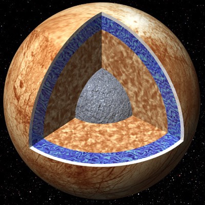
Cutway of the interior of Europa. The ice crust is 10-30 km thick, with a 100 km deep ocean of liquid water. The mantle is rocky, and there may be a small iron core.
Icy satellites are some of the most dynamic worlds in our solar system, displaying active tectonics, eruptions of ice and water, and more heat than even their terrestrial counterparts. Many of these satellites may have had subsurface liquid water oceans at some point in their past and some are suspected to harbor oceans today. Those whose surfaces display recent geologic activity are particularly suggestive of subsurface oceans. Icy satellites are perhaps the most potentially habitable spaces in the Solar System. Our group combines seismological model with investigations of Earth analogs to understand the geological processes observed on icy satellites, identify those satellites that likely possess oceans in the present day, and help propel forward the search for extraterrestrial life.
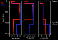
Theoretical seismic models of the Europan interior. There is a significant difference between models with a cold and hot interior. Adapted from Cammarano et al., 2005.
To study the icy crusts of the outer satellites, we are using the ice shelves and ice sheets of Earth as analog environments to study the deformation of ice and propagation of seismic waves in such environments. Many features on the outer satellites are related to tidal stresses, thus it is expected that seismicity will be closely coupled to the tidal periods of these satellites. By using the redundant information provided by repeat seismicity, we are modeling what a future seismometer on a tidally active outer satellite might image. The goal of such approaches is to determine if such information can be used to illuminate the deeper interior, putting constraints on the size of the core, mantle, and ocean layers (if present).
Additionally, recent drilling experiments in eastern Greenland revealed that there is a significant amount of seasonal water that is stored in the surface firn layer. To determine the structure of this acquifer with depth, our research group will be deploying geophones onto the surface of the ice sheet to refine the depth extent and volume of the firn acquifer. The amount of melt water present in the firn is significant and may account for a substantial amount of previously unrecognized melt.
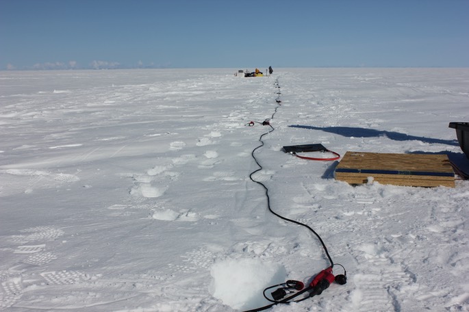
Measuring the seismic wave velocity of the firn in Greenland with an active source geophone line.
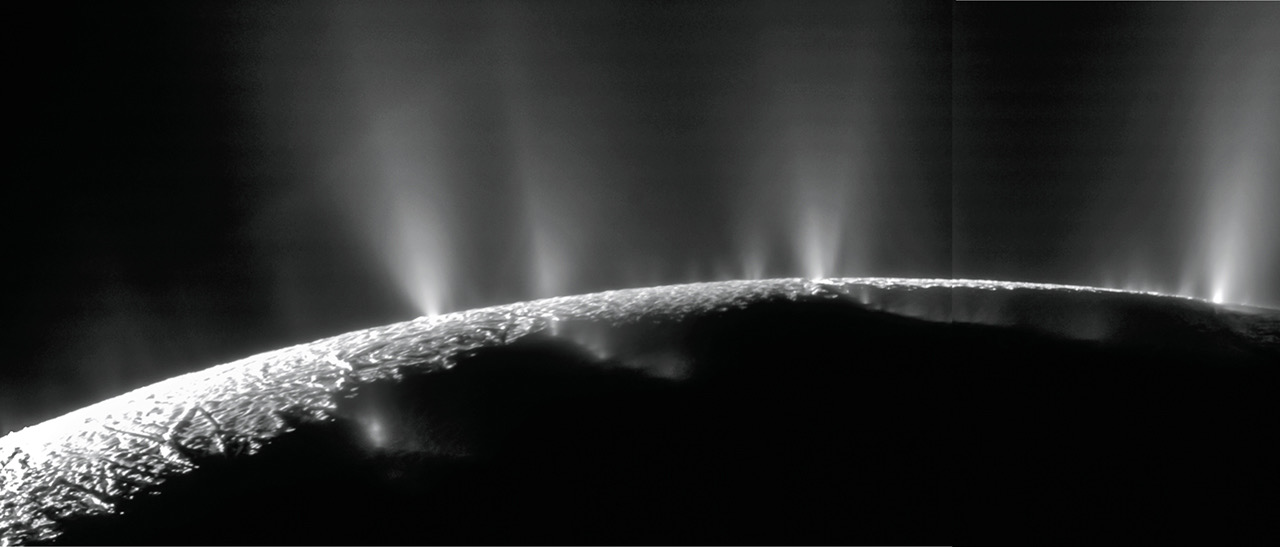
Ice plumes erupting from the South Pole of Enceladus. Photo Credit: NASA/JPL/Space Science Institute
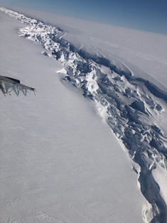
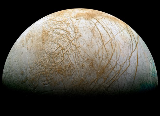
Europa and Enceladus, moons of Jupiter and Saturn, respectively, each display pervasively fractured surfaces that have been linked to tidal stress. Imparted mainly by their eccentric orbits, these satellites experience global deformation throughout each day that can lead to shear or tensile failure of the icy surface. Many characteristics of the fractures on Europa and Enceladus can be well explained by tidal-tectonic models, which assume that rifts undergo daily tidally induced motions. We are exploring a series of rifts that exist on the Ross Ice Shelf in Antarctica. These rifts are similar in scale to the Tiger Stripe features found on Saturn’s moon Enceladus, and open and close with the tides. These rifts in Antarctica that display tidal driven motions enable the direct study of tidally induced motions that are assumed in planetary tidal-tectonic models.
We are using one of these rifts to study the detailed motion in response to the tides. An array of 16 seismometers and 12 GPS stations are being used to quantify the displacement and icequake seismicity within the rift, and then build a physical model for how these rifts move in response to the ocean tide rising and falling. A recent expedition to McMurdo, Antartica set these instruments out to record for a month and log rift activity. Subsequent data analysis will reveal rift motion and allow us to study how rifts on the icy-ocean worlds would be expected to move in response to the local tidal conditions.
Relevant Work:
- Maguire, R., Schmerr, N., Lekic, V., Hurford, T., Dai, L. (2020), Constraining Europa’s Ice Shell thickness with Fundamental Mode Surface Wave Dispersion. Icarus, https://doi.org/10.1016/j.icarus.2021.114617.
- Maguire, R., Schmerr, N., Pettit, E., Riverman, K., Gardner, C., Della-Giustina, D., Avenson, B., Wagner, N., Marusiak, A., Habib, N., Isabella, J., Bray, V. Bailer, S. H., (2020), Geophyiscal constraints on the properties of a subglacial lake in northwest Greenland. Cryosphere, https://doi.org/10.5194/tc-15-3279-2021.
- Olsen, K., Hurford, T.A., Schmerr, N.C., Huang, M., Brunt, K.M., Zipparo, S., Cole, H., Aster, R. (2021) Projected Seismic Activity at the Tiger Stripe Fractures on Enceladus, Saturn from an Analog Study of Tidally Modulated Icequakes within the Ross Ice Shelf, Antarctica. Journal of Geophysical Research – Planets, https://doi.org/10.1029/2021JE006862.
- Marusiak, A., Schmerr, N.C., DellaGiustina, D.N., Avenson, B. Bailey, S.H., Bray, V.J., Brodbeck, J., Carr, C.G., Dahl, P.H., Habib, N., Pettit, E., Wagner, N., Weber, R., (2020) The Deployment of the Seismometer to Investigate Ice and Ocean Structure (SIIOS) in Northwest Greenland, Seismological Research Letters, 92(3) 2036-2049 https://doi.org/10.1785/0220200291.
- Killingbeck, S., Schmerr, N., Montgomery, L., Booth, A., Livermore, P., Guandique, J., Miller, O., Burdick, S., Forster, R., Koenig, L., Legchenko, A., Ligtenberg, S., Miege, C., Solomon, D., West, L., (2020), Integrated borehole, radar, and seismic velocity analysis reveals dynamic spatial variations within a firn aquifer in southeast Greenland. Geophysical Research Letters, https://doi.org/10.1029/2020GL089335.
- Miller, O., Solomon, D. K., Miège, C., Koenig, L., Forster, R., Schmerr, N., Ligtenberg, S. R. M., Legchenko, A., Voss, C. I., Montgomery, L., & McConnell, J. R. (2020). Hydrology of a perennial firn aquifer in Southeast Greenland: an overview driven by field data. Water Resources Research, https://doi.org/10.1029/2019WR026348.
- Marusiak, A. G., Schmerr, N., DellaGiustina, D. N., Pettit, E. C., Dahl, P. H., Avenson, B., Bailey, S. H., Bray, V. J., Wagner, N., Carr, C., & Weber, R. (2020). The Deployment of the Seismometer to Investigate Ice and Ocean Structure (SIIOS) on Gulkana Glacier, Alaska. Seismological Research Letters, 91 (3): 1901–1914 https://doi.org/10.1785/0220190328.
- Hurford, T. A., Rhoden, A., Panning, M., Manga, M., Schmerr, N., Maguire, R., Kattenhorn, S., Lekic, V., Bray, V., and Henning, W., (2020), Seismicity on Tidally Active Solid-Surface Worlds. Icarus, 338, https://doi.org/10.1016/j.icarus.2019.113466.
- Legchenko, A., Miege, C., Koenig, L., Forster, R., Miller, O., Solomon, D. K., Schmerr, N., Montgomery, L., Ligtenberg, S., Brucker, L., (2018) Estimating water volume stored in the south-eastern Greenland firn aquifer using magnetic-resonance soundings. Journal of Applied Geophysics, 150 https://doi.org/10.1016/j.jappgeo.2018.01.005.
- Legchenko, A., Miege, C., Koenig, L., Forster, R., Miller, O., Solomon, D. K., Schmerr, N., Montgomery, L., Ligtenberg, S., Brucker, L., (2018) Investigating a firn aquifer near Helheim Glacier (South-Eastern Greenland) with magnetic-resonance soundings and ground-penetrating radar. Near Surface Geophysics, 16 (4), 411-422, https://doi.org/10.1002/nsg.12001.
- Miller, O., Solomon, D. K., Miege, C., Koenig, L., Forster, R., Schmerr, N., Ligtenberg, S., Montgomery, L., (2017) Direct Evidence of Meltwater Flow Within a Firn Aquifer in Southeast Greenland. Geophysical Research Letter, 45 http://dx.doi.org/10.1002/2017GL075707.
- Miller, O., Solomon, D. K., Miege, C., Koenig, L., Forster, R., Montgomery, L., Schmerr, N., Ligtenberg, S., Legchenko, A., Brucker, L., (2017) Hydraulic Conductivity of a Firn Aquifer in Southeast Greenland. Frontiers in Earth Science, 5 https://doi.org/10.3389/feart.2017.00038.
- Montgomery, L., Schmerr, N., Burdick, S., Forster, R., Koenig, L., Legchenko, A., Ligtenberg, S., Miege, C., Miller, O., Solomon, K., (2017) Investigation of Firn Aquifer Structure in Southeastern Greenland Using Active Source Seismology. Frontiers in Earth Science, 5 https://doi.org/10.3389/feart.2017.00010.