Fall Semester 2025 Deep Time: How Old is That Fossil?
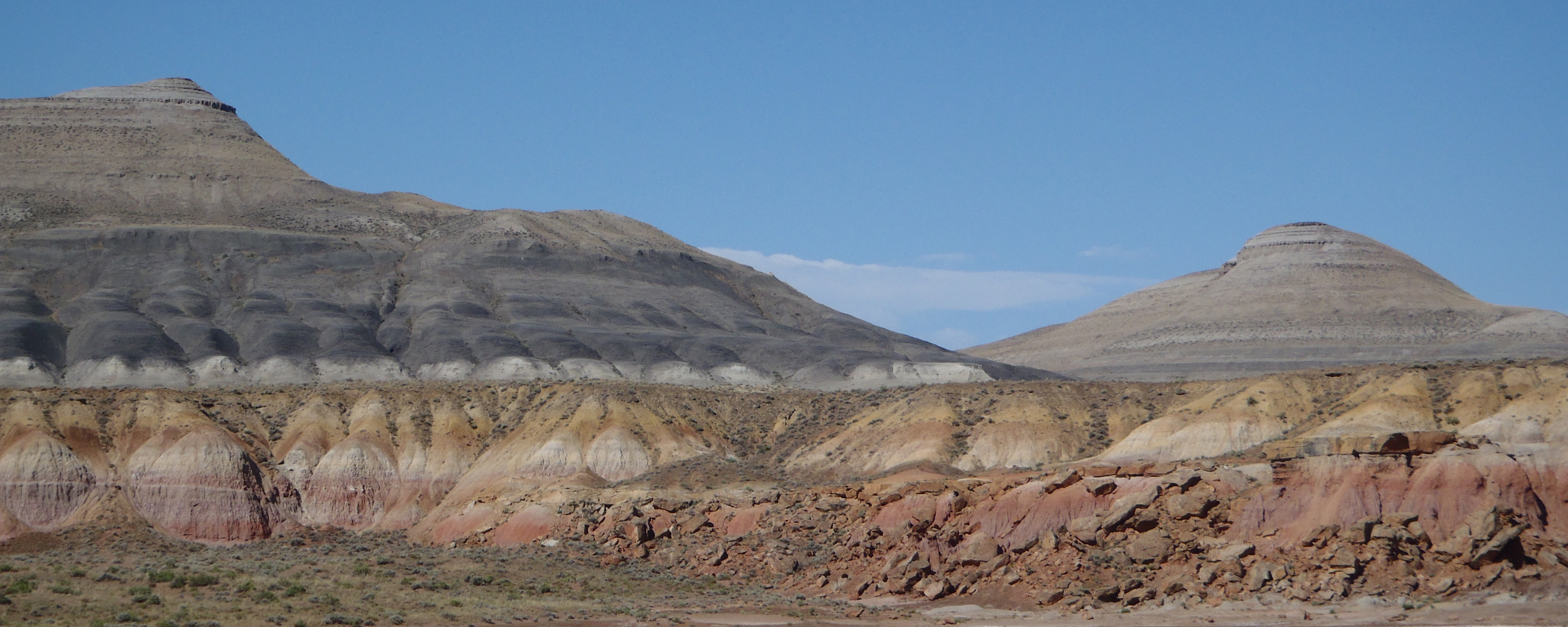
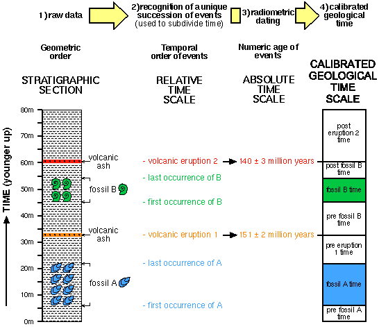
Strata from the Upper Jurassic Morrison Formation to the Upper Cretaceous Frontier Formation, Bighorn Basin, WY
Key Points:
•Relative time represents the sequence of events; numerical time is the statement of dates or durations in terms of actual measured units (years, etc.).
•Geologic time is an example of "deep time": the history of the Earth is incredibly long compared to our personal experience, being measured in millions and billions of years.
•Because they naturally form strata, the relative sequence of time in sedimentary rocks are relatively straight forward to work out.
•The physical stratigraphy (position of different strata of a given spot) allows one to figure out the sequence of oldest to youngest event at this spot.
•Correlation from one spot to another can be done by tracing out particular beds (formations), assuming the two spots are physically close; for correlation over longer distances, methods such as biostratigraphy are needed.
•Biostratigraphy uses the sequence of index fossils through different strata as markers of time.
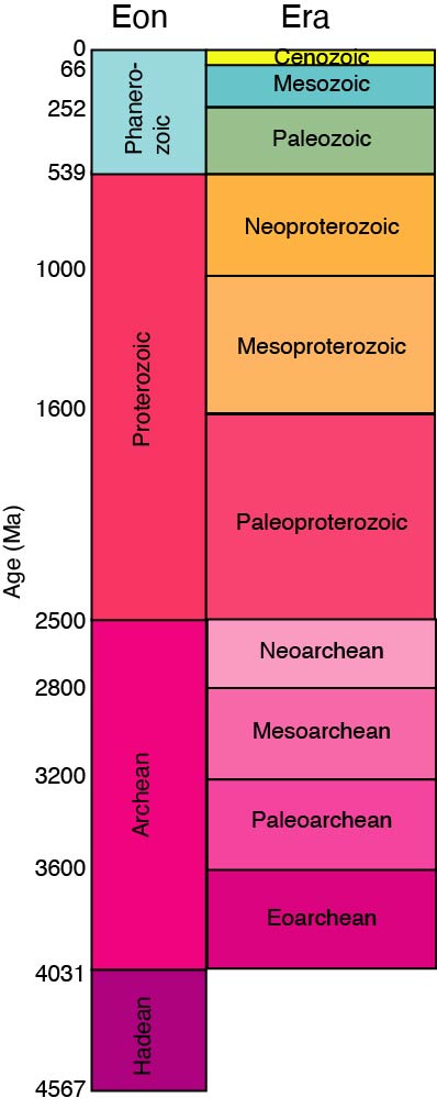
•The geologic time scale was initially developed using index fossils. It divides up the history of the Earth into Eons, which are subdivided into Eras, which are broken up into Periods, which are divided into Epochs, which are spit into Ages (or Stages).
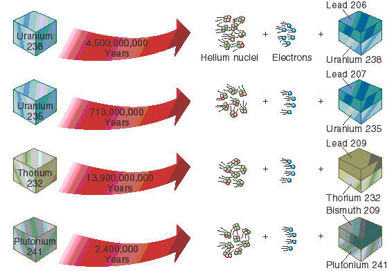
•The best estimates of numerical time come from radiometric decay. Some naturally occurring isotopes change from the parent material into the daughter product at a constant rate of decay; comparing the ratio of daughter to parent alows you to calculate the age of the rock.
•However, radiometric dating works only for igneous rocks. So you can use volcanic ash beds, lava flows, and igneous intrusions to bracket the age of the fossil bearing strata, but rarely directly date the fossils themselves.
•Other methods of determining the age of rocks include using marker beds (that document single widespread events) or tracing the flip-flop of the Earth's magnetic field over time.
Deep Time: Ruins of a Former World
"Deep Time": analogy to "deep space"; the vast expanse of time in the
(geologically ancient) past.
Two different aspects of time to consider:
Relative Time: sequence of events without consideration of amount of time
Numerical Time: (sometimes called "absolute time"), dates or durations of events in terms of seconds, years,
millions of years, etc.
Relative time was determined LONG before absolute time.
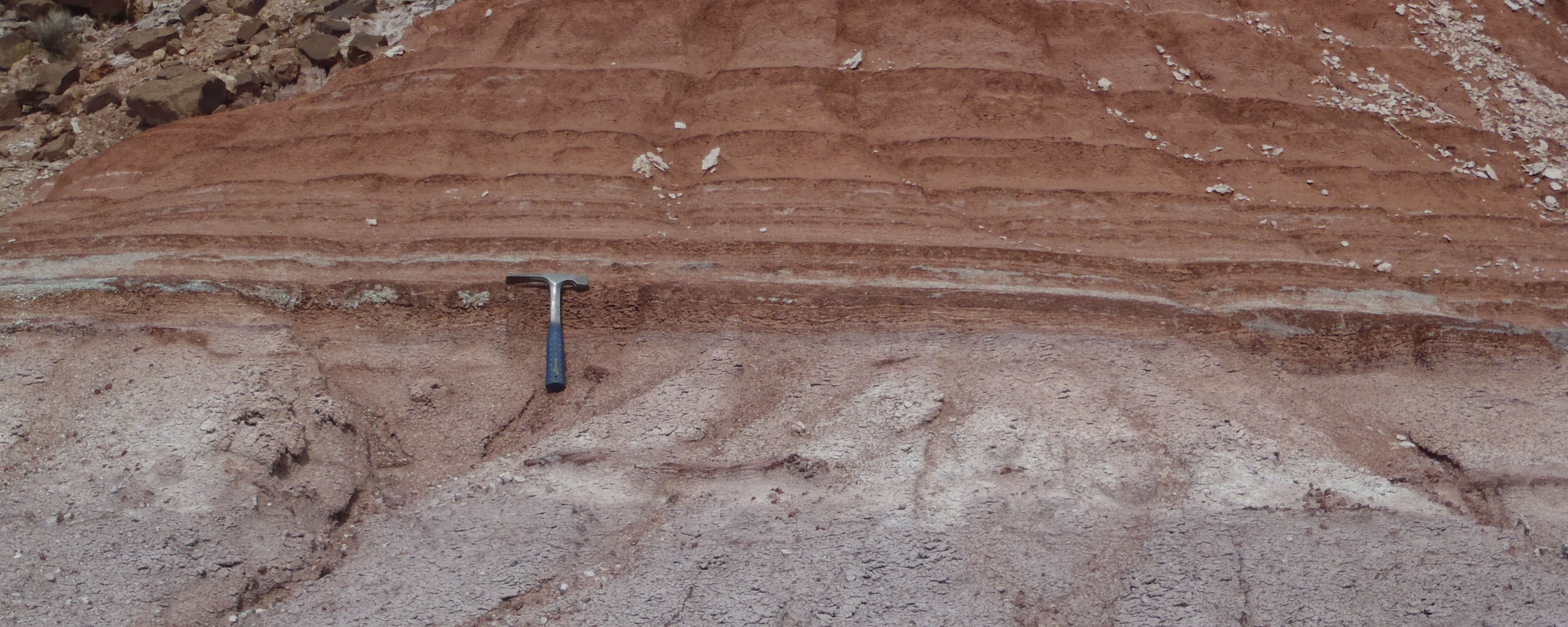
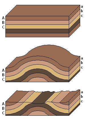
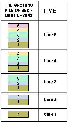
Sedimentary rocks naturally form horizontal layers (strata, singular stratum).
Strata allow geologists to determine relative time (that is, sequence of deposition of
each layer, and thus the relative age of the fossils in each layer):
Principle of Superposition:
unless they have been disturbed, the strata at the
bottom of a stack were deposited first, the ones on top of that are next oldest, and so
on, with the youngest strata being the ones on top.
(A note: there are often gaps in the rock record, caused by either periods of non-deposition or periods of erosion. These will fall
in superposition order, but mean that
any given section of rock won't have the complete record of all geologic time. These gaps are reflected as weathering surfaces or
erosional surfaces (technically called unconformities)
Principle of Cross-cutting Relationships:
any structure (fold, fault, weathering surface, igneous rock intrusion, etc.) which cuts
across or otherwise deforms strata is necessarily younger than the rocks and structures it
cuts across or deforms.
In some cases, the particular rock type, color, sedimentary structures, and so on
were the same in strata in nearby sections. These groups of strata were named
formations:
Represent units of rock produced by the same conditions (environment) and having the
same history (produced over a particular sequence of time)
Given formal names (e.g., the Morrison Formation, the Hell Creek Formation, the
Solnhofen Limestone, etc.)
Sometimes groups of formations which lie directly on top of or next to each other are
catalogued together as formal Groups, and sometimes groups which lie directly on
top of or next to each other are placed into formal Supergroups
Mapping out formations, groups, and supergroups, geologists could connect sequences of rocks across regions. But what about across continents and oceans?
Needed a new method of correlation. Rock type doesn't work, because the same
environment will produce the same rock type regardless of relative or absolute time.
Fossils, however, were useful:
Principle of Fossil Succession: there is a unique, non-repeating pattern
(history) of fossils through stratigraphic time. All rocks containing fossils of the
same species were deposited during the duration of that species on Earth.
Fossils allowed correlation from continent to continent. Only certain types of fossils
(called index fossils)
are useful for correlation. To be a good index fossil, the species should:
Have been VERY common, so chances of individuals being buried is good
Have hard parts, so chances of fossilization are good
Have a wide geographic range, so that correlation over wide region is possible
Lived in (or could be deposited in) different environments, so can be found in
different formations
Have some distinctive features, so it can be recognized from closely related
forms
Have a short geological duration (a few million years at most), so finding a fossil of the species in a rock means it had
to be deposited in those few million years
Using index fossils, geologists were able to correlate across Europe, and then to other
continents. Created a global sequence of events (based on the sequence of (mostly
European) formations and the succession of fossils) termed the Geologic Time Scale.
Became a "calendar" for events in the ancient past: used to divide up time as well
as rocks.
Geologic Column divided into a series of units: from largest to smallest Eons, Eras,
Periods, Epochs, Ages.
Animal and plant fossils are mostly restricted to the last (most recent) Phanerozoic
Eon ("visible life eon"). The Phanerozoic Eon is comprised of three Eras:
The Paleozoic Era ("ancient life era")
The Mesozoic Era ("middle life era"): the Age of Dinosaurs
The Cenozoic Era ("recent life era"): the Age of Mammals. We are still in the
Cenozoic Era.
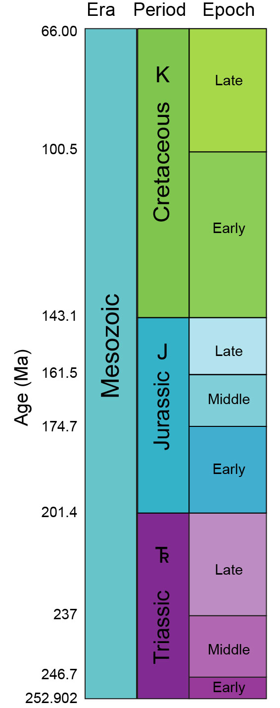
The Mesozoic Era is divided into three periods:
The oldest (furthest from us in time) is the Triassic Period
("three-fold period"), comprised of the Early Triassic, Middle Triassic,
and Late Triassic Epochs
The middle one is the Jurassic Period ("Jura mountain period"), comprised of
the Early Jurassic, Middle Jurassic, and Late Jurassic Epochs
The youngest (closest to us in time) is the Cretaceous Period ("chalk period"),
comprised of only the Early Cretaceous and Late Cretaceous Epochs.
No one region has a continuous sequence of time. Any given location has likely had periods of non-deposition or erosion, which would leave gaps in the geological and fossil record at any given spot.
An
interactive project on geologic time, for those who want to explore in more detail.
Although the Geologic Column was developed as a relative time scale, geologists wanted
to figure out the numerical age dates for Era-Era boundaries and other events.
Discovered various techniques:
Main one: Radiometric dating
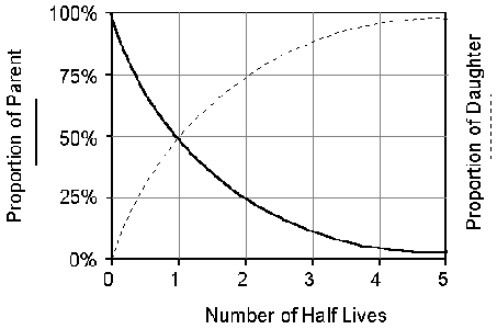
Radioactive materials decay
at predictable rate, known as the half-life
Atoms decay from one form (parent) to another (daughter product), releasing energy
and particles
After one half-life has passed,
half the original parents in the material will have decayed into the daughter product;
after two half-lives, only one-quarter of the parent material remains, with three quarters
daughter product; after three half-lives, 1/8 to 7/8; after four half-lives, 1/16 to 15/16;
and so on.
Can thus date rocks:
Compare the ratio of parent product to daughter product
Radiometric dates will only be effective for igneous rocks, since those are the ones
that form by cooling and locking atoms into place
In sedimentary rocks, can date the individual grains of sediment: tells you age of
source rock, but not deposition
In metamorphic rock, recrystallization redistributes atoms and obscures signal
Since only igneous can best be dated radiometrically, use principles of superposition,
cross-cutting relationships, etc., to determine ages of sedimentary rocks (and their
fossils) relative to numerical dates, and tie dates into Geologic Column by correlating with index fossils
Note: radiocarbon (carbon 14) dating cannot be used for Mesozoic fossils!
Half-life is WAY too short; only useful for tens-of-thousands-of-years scale.
Marker Beds
Some large geologic events (major volcanic eruptions,
asteroid impacts, etc) leave a characteristic thin layer of rock across wide regions
(sometimes globally)
Magnetostratigraphy
The magnetic (but NOT the geographic) poles have "flip-flopped" throughout geologic time, so that sometimes a magnet's north pole points
towards geographic North, and sometimes toward geographic South.
Magnetic polarity can be recovered by some iron-bearing rocks (sedimentary and igneous).
Because based on the Earth's magnetic field, the changes occur everywhere on the
planet at the same time.
Can use the particular "bar code"-like pattern of flip-flops to match any section to
known global pattern (based on continuous record of lava on ocean floor)
Radiometric dates reveal the Paleozoic-Mesozoic boundary is 251.902±0.024 Ma (million years ago);
the Triassic-Jurassic boundary is 201.4±0.2 Ma, the Jurassic-Cretaceous boundary is 145.0 Ma,
and the Mesozoic-Cenozoic boundary is 66.0 Ma. (These represent recent recalibrations; many texts and figures show slightly different numbers for these based on pre-2013 calculations.)
Most effective approach in getting age dates for a fossil bed is to combine multiple
techniques: get relative age relationships between local units, find index fossil ages
for the sedimentary rocks, and radiometric and magnetic dates where possible.
Here is a nice set of graphics to
put the scale of geologic time in perspective.
Some relevant videos:
An 11 minute history of the Earth, shown at a constant time rate (dinosaurs only show up at around 10:40):

